
It is widely believed that knowledge of agriculture, the skill of making advanced tools, the power of fire and the ingenuity of the wheel likely advanced mankind and society. By studying pre-historic settlement patterns much can be learned about prehistoric man’s ability to read the landscape and choose where to settle in it. The availability of water, arable land and building materials could have triggered the pre-historic people’s preference for some places and sites over others. As a survival factor, lands with arable soils and hospitable climate plausibly became places of convergence for pre-historic people. More people conceivably led to more interaction, shared well-being and defensibility of shared resources. The idea of sharing, traditions, memories and rituals then, perhaps may have been cultivated along with land. Death and loss was probably mourned as a community. Over time, the evolution of burial rituals took root. A megalithic settlement, for example, can be read along the above lines, to understand pre-historic people’s view of their environs.
Megalithic communities have left us with more burial sites than settlements which give us insights into their belief of permanence and life after death. The relatively ephemeral construction of habitation sites and dwellings suggests that these people settled in a temporary manner and migrated in search of new resources when challenged with the lack of it. These structures and the remains buried along with the dead are a testimony to the much prevalent belief system of ‘afterlife’ and ‘rebirth’.
It cannot be missed that these burials needed a fair amount of planning, preparation and manual labour of at least twenty odd people considering the extent of excavation involved and size of stones used in many cases. In the Deccan, Karnataka and Andhra Pradesh have many megalithic cultures – across most of them, the burials are seen close to a hill or on an elevated rocky terrain which provided raw materials for its assemblage. The habitation sites are closer to the waterways at lower elevations with arable soils.
Many Megalithic communities buried their dead at sites away from water resources and arable land. The idea of selecting such sites away from water was perhaps intended to preserve mortal remains. Even today, spending a few hours at these sites – many of them barren- only makes us aware of the harsh conditions of these lands. This perhaps ensured that the dead or the people working on the burial sites were not attacked by wild animals. However, it is also likely that the environs one sees today have been significantly altered by large impact factors such as droughts and famines. What then, was the biological and physical quality of these landscapes in the time of the megalithic communities that traversed them?
One may then take cues from geology and geomorphology which encompass larger timelines. It can certainly equip our understanding about the availability of water and the permanence of its occurrence which closely influences selection of a habitation site. Finer readings of topography, fractures, dykes and soil can present an interconnected indication of the success of a settlement.
Devarayanadurga is one such example which must have offered possibilities of providing for habitation sites with the Irakasandra lake as a reliable resource. What we notice today is a barren landscape dotted with numerous prehistoric burials. The settlements have been erased over time but the burials have remained.
Megalithic Site at Devarayanadurga
Latitude : 13° 25' 53.12" N, Longitude: 77° 14' 4.36" E, Altitude : 820 - 835 M MSL
This parcel of land falls on to the West of the KA SH 3 (Karnataka State Highway 3) at the base of the northern extent of Devarayanadurga hillock. It primarily is an agricultural land with large gneissic rock outcrops which surface above the ground level. Pongamia (honge) tree clumps along with Sitafal trees criss-cross the site and define the arable pockets by forming hedgerows.
The area being referred to is roughly 150 M x 150 M (i.e. 22,500 Sqm / 5.5 Ac). This land is not as water sufficient compared to the land enclosed within the ‘C’ shaped Devarayanadurga hillock which naturally drains into the Irakasandra lake onto the East and extends further towards the North-east.


This belt is dotted with settlements such as Anupana halli, Tangana halli, Neelagondanahalli, Sankenahalli , Irakasandra, Yalerampura and so on. From what it may seem, the burial site may have been consciously located away from the natural and efficient water holding belt.
Megalithic Structures
There are 5 types of megalithic structures seen here; Menhir, Cists, Dolmenoid Cists, Dolmenoid Cists with Single Cairn circle, Dolmenoid Cists with Double Cairn circle
All the structures are made by extracting rock from the existing outcrops.Leftovers or unused pieces are seen on the rock outcrops which match in thickness to the capstones. Potsherds and microliths are seen in the tilled soil. Fragments of black ware and red ware have been observed at the site.


MENHIR
Latitude : 13° 25' 53.12" N, Longitude: 77° 14' 4.36" E, Altitude : 820 - 835 M MSL
A large, roughly dressed Gneiss stone slab, approximately 13 feet tall and 15 inch thick (at the base) stands as an isolated feature amidst vast agricultural land. It faces North and is at a slightly elevated ground as compared to its southern side. There is a mound –like formation of about a foot and half high onto the southern side covered with rubble, this probably was necessary to provide a buttress/support to the menhir and grade the land which gradually dips down.
This ‘menhir’ probably was laid out as a marker to the Megalithic burial site. The actual extent of the burial site cannot be determined, but seemingly extends towards the base of Devarayanadurga hill which is located to the West of the erected menhir.

CISTS
Latitude : 13° 25' 52.4797" N, Longitude: 77° 14' 2.3405" E
There are about 7 cists in the explored extent of the site. These cists are rectangular in plan and are buried. The walls are made out of 4inch thick stone, four in number and the plan dimensions are roughly about 7’-0” x 5’-0”, except for one which measures 5’-10” x 5’-0”.Only one cist appears to have a porthole. It is not known if the capstone has been removed from these locations.

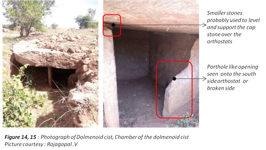
DOLMENOID CIST
Latitude : 13° 25' 53.12" N, Longitude: 77° 14' 4.36" E, Altitude : 820 - 835 M MSL
A rectangular parcel of land, to the north of the menhir is dotted with about 5 to 6 dolmenoid cists. The cap stone is burried under the packing in some cases and slightly project above the surface in a few. Two such cists are exposed and hence reveal the structure within.
The cist to the East of the menhir is partly dug up and deep, whereas the cist 60 feet away towards the North is opened up. The cap stone is approximately 18-20 inches thick and measures 12 feet at the diameter, rather a polygon. In plan there is a small three sided chamber made out of 4 inch thick roughly dressed stone verticals. The capstone rests on vertical supports and partially on the ground along the edges. The capstone packing varies in thickness (1’-0” thick at the centre) and consists of rubble along with soil.

DOLMENOID CIST – SINGLE CAIRN CIRCLE
Latitude : 13° 25' 53.742" N, Longitude: 77° 14' 3.618" E, Altitude : 845.20 M MSL
A cluster of 6 dolmenoid cists with single cairn circle are observed with intact capstone packing. At one end of the cluster is a cist and at the other end is a rock outcrop. There are 2 circles which measure 26’-0” in diameter and the others around 20’-0”. The cap stone is buried except for one, where the vertical stone supports are seen.

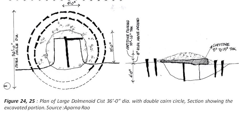
DOLMENOID CIST – DOUBLE CAIRN CIRCLES
Latitude : 13° 25' 56.01" N, Longitude: 77° 14' 2.058" E, Altitude : 836.90 M MSL
Further inside towards the West, large double cairn circles dot the site. The diameters vary from 20feet to 36feet with a dolmenoid cist at the centre covered with a capstone. These burials have 2 concentric rings with 3 to 4 inch thick stone inserts which are buried below ground up to a depth of 3feet or more.
These graves are partially exposed and reveal the depth as the land dips onto the west by at least 3feet. The portholes are seen on the west-side wall of the chamber which invariably house a tree or large shrub.

The double cairn circle with a broken capstone over the cist shown above is oriented in North-South direction and has a port-hole onto the west. This porthole is v shaped unlike the others which are circles.

Latitude : 13° 25' 56.778" N, Longitude: 77° 14' 2.214" E, Altitude : 836.6 M MSL The double cairn circle shown below is oriented at a 45 degree angle unlike the others. It is exposed onto the South where the 8inch thick capstone is seen.


Latitude : 13° 25' 55.778" N, Longitude: 77° 14' 2.1341" E

Landscapes of death have always been a subject of intrigue across cultures. Some may disagree, but, the prognosis of “life” is “death”. The act of living itself is temporary while death is a certainty and ends the unpredictable cycle. It is probably this very reason as to why death is valued over life – for its permanence and in-transience.
The fact that these sites have survived a few thousand years gives us an insight into man's deep understanding of landscape as both a provider and a preserver.
Author : Aparna Rao